
After a good night’s rest at Rearguard camp, we awoke early next morning to sunshine and blue skies and a promise of a great dayhike. The rain from the previous night had cleared and the forecast was good – perfect to explore the Berg Lake surroundings. When researching the numerous trails in the area, we had already decided to hike to Snowbird Pass, and our timing was ideal. The trail is normally closed to hikers during May and June due to caribou calving, but today was July 1 – the opening day for the summer season. What a great way to celebrate Canada Day!
Click here for an outline of our Rocky Mountain adventure
We fully expected the Snowbird Pass hike to be quite challenging. Starting at Rearguard camp, the hike is a 25 km roundtrip distance across rocky terrain and switchbacks to the eastern boundary of the provincial park. It’s a long, strenuous day rewarded with spectacular views of the Robson Glacier, a beautiful alpine valley, and a vast icefield beyond the pass. After a hearty breakfast, we packed our lunches, snacks, and plenty of water in our daypacks, and set out on the trail.

Rearguard Mountain and Mount Robson as seen from our camp site. Beats any hotel room view!
Along Robson Glacier
The trailhead is located near the Rearguard campsite and the path starts level next to the river, winding its way through shrubs and bushes opposite the imposing presence of Rearguard Mountain. This portion of the hike is on the moraine of the Robson Glacier which, as you round Rearguard, comes into full view. As you approach the toe of the glacier, the path steepens considerably and the real climbing begins. A number of switchbacks ascend the mountainside where the view of the Robson Glacier and the rear of Mount Robson is breathtaking. Along the way, several large and small waterfalls and streams make for good resting areas.

The start of the trail near the river, and rounding Rearguard Mountain.

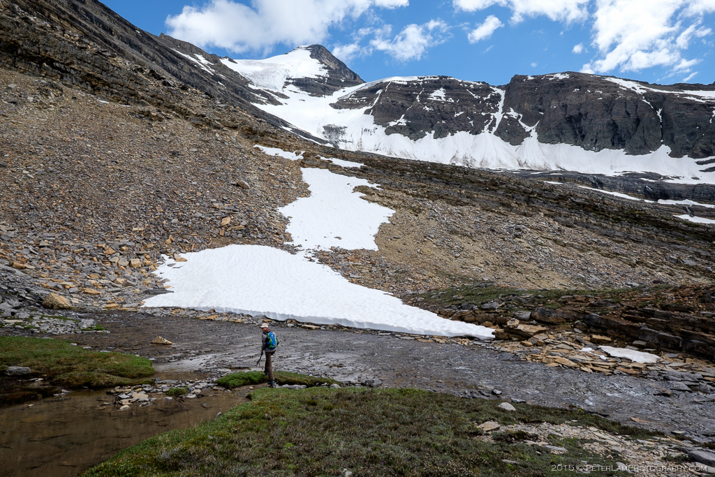
An indication of just how far the Robson Glacier has receded over the years.

Wildflowers and shrubs on the moraine trail.

At the foot of the glacier.

The climbing starts in earnest. This point marks where the Snowbird Pass is closed during caribou calving season.

A particularly steep section of the path.

The enormous Robson Glacier making its way from Mount Robson around the backside of Rearguard Mountain.

Another view of Robson Glacier from one of the many streams feeding the river below.

One of the waterfalls where we breaked for lunch.

Delicate wildflowers on the trail.

Waterfall along the scree slope trail.

One last hill to climb before reaching the meadows.
An Alpine Meadow
As you make your way past Mount Robson, the path veers east away from the glacier onto a magically green alpine meadow with crystal clear streams and bursting with wildflowers. A truly rewarding sight after the strenuous ascent up the mountainside. It looked like a scene out of Middle Earth! On both sides the valley was surrounded by snow-capped peaks and we could hear birds chirping; marmots would emerge from their dens and curiously watch their human visitors. An unforgettable, surreal experience.

Stream running through the lush and picturesque alpine meadow.

Stay on the trail so as to not disturb the delicate plant life.

Snowcapped peaks on all sides of the valley.

Can you spot the mountain sheep?

Looking back through the valley with Mount Robson in the distance.
Up Snowbird Pass
As we crossed the meadow, the final destination of the hike came into view: we could see the Snowbird Pass just ahead, in the saddle between two peaks. We were all pretty tired, but having come this far, we were determined to complete the hike. After a short break, we started our final push to the end: following the trail marked by rock cairns, an increasingly steep scramble up a scree slope to the Pass. After crossing one last snow patch, we reached the end of the trail: a steep cliff and a precipitous drop to the Reef Icefield below. Looking across the vast expanse of ice separating British Columbia and Alberta, we took a well-deserved rest and quietly contemplated our achievement.
After the elation, the sobering reality of the long return hike to the campsite. We traced the same route back through the lush green valley, then descending the rocky mountain slope to the foot of Robson Glacier in the strong early evening sun. Ten hours after we had set out on our trek, we returned to Rearguard camp. Everyone was exhausted but the exhilaration of completing this beautiful and challenging route made this the best Canada Day ever.
After the meadows, a hike through snow and rocky terrain.

Snowbird Pass is just beyond the saddle on the right.

Half way up, a great view of valley below and Robson Glacier beyond.

The final push to the end. Up the saddle we go!

Cross the snow for the end of the Snowbird Pass trail. This isn’t a fisheye lens – it’s the real curvature of the saddle.

Looking up one of the peaks.

The end of the trail. Across the ice is Alberta.

A steep drop below to the Reef Icefield.

We brought our little flag just for this occasion. There’s no better way to spend Canada Day.

On the long trail back to the campsite.

Sun beginning to set as we neared the end of our hike.

Finally back to the campsite, and a well-deserved dinner with a gorgeous view.
——————————————————————————————————

When was the trail to snow bird pass opened? I was there in 1977 ; there was no note of it .. only tobbagan falls.we explored a small ice cave at the toe of the Robson glacier. I am not sure if there was a marked trail back then also I am sure the glacier was bigger then.soounds like you had a great time.thanks for sharing your pictures
LikeLike
George, when we were there the pass was open on July 1 (Canada Day). So we actually hiked it on the first day it was officially open for the season. We didn’t actually plan it this way, but the timing was very fortunate for sure! I don’t know when the trail was ‘created’ though – probably as you said, the glacier was much larger when you visited.
LikeLike